 ™
™TRADITIONAL MOUNTAINEERING
™
www.TraditionalMountaineering.org
™ and also
www.AlpineMountaineering.org
™
™
FREE BASIC TO ADVANCED
ALPINE MOUNTAIN CLIMBING INSTRUCTION™
Home
| Information
| Photos
| Calendar
| News
| Seminars
| Experiences
| Questions
| Updates
| Books
| Conditions
| Links
| Search
![]()
Bend father-son snowmobilers lost overnight
Bend father-son snowmobilers lost overnight
by Kim Toban
February 25, 2013
KTVZ.COM
Happy ending: Lost Bend dad-son snowmobilers found
A Bend man and his 13-year-old son are sharing their story, offering thanks to rescuers --
and sharing possibly life-saving advice
after they got lost, their snowmobiles ran out of gas and they spent Sunday night huddled in a snow cave south of Elk Lake.
"Thank you doesn't do it," said Eric Abney, 40. "Tonight was going to be rough. What do you say? Thanks!"
Eric and his son, Hunter, set out Sunday afternoon a day snowmobile ride from Edison Butte Sno-Park.
Abney said the two had originally wanted to park their pickup and trailer at
Wanoga Sno-Park. But Wanoga was packed for a weekend event, so the father and
son took the recommendation of others and headed to Edison.
Unfamiliar with the area, they grabbed a map and set out.
"First turn out of there, we thought we were going left on the 43 Road to the
4," Abney said. "But apparently we turned left on the 3."
The two figured out their mistake, but harsh weather moved in and their GPS
could not get a signal. They traveled until they found a Forest Service road and
a sign that said Edison Butte Sno-Park, 14 miles ahead.
"I thought, 'Oh great, we are there," Abney said. "Eleven miles later on the
trail we hit a tee and no sno-park, so something happened. We went back to the
intersection, tried again, still couldn't find Edison Sno-Park."
As night fell, they decided to head for Elk Lake, but one of their sleds ran out
of fuel. As they made it to the Cascade Lakes Highway, the second one ran out as
well. That's when they decided it was time to set up camp.
"Then we dug a snow cave, the cold was setting in," Abney said, "and wow -- the
cold comes fast."
They built a snow cave, lined the floor with tree boughs, started a fire and
began to melt snow for water. Eric Began signaling SOS. with his flashlight in
the tallest Ponderosa nearby, hoping someone would see them.
As Monday morning arrived, friends and family became worked and called for help.
For hours, nearly 100 people searched for the father and son lost in the woods.
Monday afternoon, Hunter's feet became cold and he was in much pain. His father
bundled up his son in the snow cave and set out for help.
Eric Abney said he planned to travel on foot for one hour, then return back to
his son if he didn't find help.
But just before 1:30 p.m. Monday, Hunter was found in his snow cave by a passing
snowmobiler.
"When he left, I just kind of laid down and listened," Hunter Abney said later.
"Snowmobiles came by, and I just had a mini-heart attack and jumped out and
yelled, 'Hey! Hey!"
A short time later, his dad was found about a mile away, and the two were taken
back to Mt. Bachelor, where searchers had set up their command post.
Eric and Hunter say they will return to the mountains again. But Eric says he's
glad he was prepared for the worst.
"Ask yourself that question: 'I'm going to spend the night on the mountain
tonight. What do I want with me?' Abney said. "If you don't bring it, you don't have it."
--Copyright 2013 KTVZ. All rights reserved.
Comments published with the above KTVZ.com news report:
Robert Speik:
Eric Abney, 40, and his son Hunter Abney, 13, were Prepared for their
backcountry stranding from Sunday afternoon to noon on Monday, February 24 and 25, 2013.
However, a few comments might help others to avoid an overnight stranding that was by no means inevitable.
Eric Abney, according to an interview in the Bend Bulletin, is a 16 year Air
Force Veteran who specialized in combat rescue in Afghanistan. Eric and Hunter
were Prepared with warm clothing and head covering suitable for withstanding the
wind and weather encountered by snowmobiles at speed, carrying on their snow
machines, two shovels and a saw, blankets to insulate them from the snow and
easily digested high carbohydrate snack foods and some water, although perhaps
not enough water.
Eric left his cell phone in the truck because the “batteries were nearly dead”.
However, they did not intend to be gone for long, he said.
Does it follow, that if you do not intend to become lost and stranded, you do
not need to carry a simple means of emergency Communication?
A cell phone will not work in the backcountry? The Organizers of the current
“Bachelor Butte Dog Derby” have confirmed over several years that Verizon cell
phone towers cover the Backcountry west of Bend.
Ordinary cell phones have assisted the timely resolution of almost every
stranding in the Three Sisters Wilderness in the past several years.
Deschutes County Sheriffs Search and Rescue Volunteer Coordinator Al Hornish, a
12 year veteran of DCSAR, stated the following in an interview published on
January 26, 2012 in the Bend Oregon Source Weekly: "We have grown a lot over the
past decade." "The nature of missions has changed as well. There are more
Rescues and less Searches, mostly because of the better technology available."
Eric Abney picked up a trail map at Edison snow-park. However, it is best to be
Prepared with maps of the snowmobile trails for the pocket of each rider, before
you leave home for the trail head. The Central Oregon Snowbusters annual
snowmobile topo trail maps are free at shops and at the Deschutes National
Forest Headquarter in Bend, and sometimes, at trail heads.
The KTVZ.com interview notes that “harsh weather moved in and their GPS could
not get a signal”. It is not widely understood that a hand-held GPS such as their
Garmin GPS Map 60 CSx uses radio signals between it and the DOD GPS constellation of
satellites and is not affected by tall trees, clouds, rain or snow or dark of night.
However, to be useful, a GPS must be set-up, loaded with local topo maps of
Oregon, and then have Waypoints selected.
Eric and Hunter dug out a snow drift at the side of Cascades Lakes Highway, with
their two snow shovels, cut limbs and small trees with their saw and lay on
boughs and blankets dressed in their snowmobile suits and headgear. We note that
Hunter’s feet became cold. We suggest this may have been from 13 year old feet
outgrowing his boots. Tight boots can constrict blood vessels and lead to
serious cold injuries.
It must be noted that family member Leroy Abney was expecting them to be home
“by 5:30 pm Sunday. He became worried. He finally called 911 early Monday
morning triggering the search by about 70 people including about 30 local
Snowmobile Club Members.
An appointed Responsible Person must confirm that they will call 911 at an
agreed time, say 6 pm. This planning may avoid a cold overnight stranding. A
phone call to 911 is cost free; hypothermia can take the life overnight, of an
injured person lying in the snow.
Eric and Hunter say they will return to the mountains again. But Eric says he's
glad he was prepared for the worst. "Ask yourself that question: 'I'm going to
spend the night on the mountain tonight. What do I want with me?' Abney said.
"If you don't bring it, you don't have it."
I think a better question might be “How can I avoid becoming stranded over night in the Backcountry of Central Oregon?”
Happy ending: Lost Bend dad-son snowmobilers found
MT. BACHELOR, Ore. -
Got turned around, ran out of gas; spent night in snow cave
KTVZ
By Kim Tobin
February 26, 2013
Deschutes County Sheriff's Office
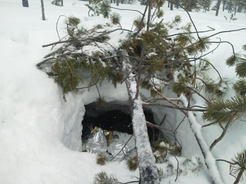
Eric Abney built this snow cave to protect himself and son Chase, 13, Sunday
after their snowmobiles ran out of gas south of Elk Lake, officials say:
A Bend father and his 13-year-old son whose Sunday snowmobile outing turned into
an unexpected test of survival after they got turned around, ran out of gas and
were found separately in good condition Monday afternoon near Elk Lake, more
than 10 miles west of where they began.
It was a happy end to a major and growing search effort involving dozens of
volunteers and Deschutes County sheriff's deputies, among others.
"We get worried, just like anybody else," said Deschutes County sheriff's Capt.
Shane Nelson. "When we respond to these incidents, we cannot help but relate it
to our own personal experiences, and our own families."
Around 1:20 p.m. came word that the boy, Chase Hunter Abney, had been found by a
man on snowmobile, about five miles south of Elk Lake Resort (west of Mt.
Bachelor) on snowmobile Trail 5, apparently in fair condition, Nelson said.
The teen said he and his father, Eric William Abney, 40, of Bend, had been
snowmobiling when they got turned around in the wilderness, took a wrong fork in
the road and ran out of gas about five miles south of Elk Lake, on snowmobile
Trail 5.
Nelson said the father dug a snow cave for shelter, lined it with tree boughs
and started a fire for warmth on a night when temperatures plunged well below
freezing, with new snow falling in the area.
The father had left the snow cave shortly before 1 p.m. Monday to hike out and
get help. He was located around 2:20 p.m., apparently in good condition, Nelson
said.
A SAR member radioed to the command post at Mt. Bachelor ski resort that the
father was "in his own words, ambulatory and in good condition -- a little
hungry, a little thirsty, but in great shape."
Searchers had said the family reported they were experienced, well-equipped
snowmobilers -- and the happy ending to the search appeared to bear that out.
Nelson said the father and son were checked at the scene by SAR medics and did
not require medical attention.
Sheriff Larry Blanton told NewsChannel 21 that he and the rest of the searchers
were "very grateful" for the successful outcome in the cold, snowy backcountry.
"They don't all end that way," Blanton added.
Searchers fanned out to look for the pair after their pickup and empty
snowmobile trailer were found around 7:30 a.m. at Edison Butte Sno-Park, east of
Mt. Bachelor and about 20 miles southwest of Bend.
Family members called Deschutes County 911 dispatchers shortly before 7 a.m.
Monday to report the pair had left Sunday to go snowmobiling near Mt. Bachelor
but failed to return, said sheriff's Capt. Shane Nelson.
Family members said the father and son were prepared for the weather, adequately
dressed, with food and water and possibly survival-type gear, Nelson said.
The family didn't know which sno-park they were planning to depart from, so a
search got under way, which led to the pickup and trailer at Edison Butte
Sno-Park.
Several teams of searchers were headed out, including Sheriff's Search and
Rescue volunteers on snowmobiles, amid blowing snow and reports of zero
visibility at times in some areas.
By the time it ended, about 70 searchers were involved in the operation,
including about 30 volunteer riders with two local snowmobile clubs, the Central
Oregon Snowbusters and La Pine Lodgepole Dodges. Also, Oregon State Snowmobile
Association groomers were reassigned to the area to help in the search, Nelson
said.
"When we know we're out there looking for other people's family members, that
has a heavy emotional impact on us," Nelson said. "So I can't tell you the huge
relief that we have. I am absolutely pleased that we have located the father and
son."
Sgt. Bryan Husband said the searchers had been looking for a pair of 2005
Skidoo
snowmobiles in the area. Shortly after the pair were found, Nelson outlined the
resources as follows:
•Six experienced snowmobile teams of two were searching the trails accessible
from Edison Snow Park.
•Snowshoers were also hiking into shelters not accessible via snowmobile trails.
•Trailheads were being covered, asking the public for any information about
possible sightings in the high country.
•Medical personnel were staged at the command post for deployment if needed.
•Air resources were lined up when weather permitted to fly.
•Snow cats were deployed focusing on the shelters in the high country.
•Approximately 28 volunteers from two area snowmobile clubs were being deployed
with DSCO SAR volunteers.
•A command structure of Sheriff’s Office personnel and SAR volunteers were
planning the next steps in the operation and will be located at Mt. Bachelor.
"Once again Mt. Bachelor is opening their facilities to SAR for this operation –
which is greatly appreciated," the news release said.
The incident command post was set up at Mt. Bachelor's West Village Lodge.
Resort personnel cordoned off areas for SAR use, also providing food and hot
drinks to searchers, Nelson said.
Copyright 2013 KTVZ. All rights reserved.
What can be learned from this interesting incident?
We have been unable to talk to the stranded snowmobilers. Federal HIPPA privacy laws prevent medical personnel, including SAR Volunteer Units, from providing contact information for patients. If Eric Abney of Oregon will contact us, we will correct any inaccuracies in our analysis. This analysis is not a 'could-a, would-a, should-a exercise', but a traditional effort to help folks learn valuable lessons from the experiences of others.
Comments:
1.
Eric Abney, 40, and his son Hunter Abney, 13, tried to be Prepared for their
backcountry stranding from Sunday afternoon to noon on Monday, February 24 and
25, 2013.
However, a few comments might help others to avoid a similar overnight stranding,
one that
was by no means inevitable.
2.
Eric Abney, according to an interview in the Bend Bulletin, is a 16 year Air
Force Veteran who specialized in combat rescue in Afghanistan. Eric and Hunter
were Prepared with warm wind and rain proof clothing and head covering suitable for withstanding the
wind and weather encountered by sitting on snowmobiles at speed and carrying on their snow
machines 'two shovels and a saw, 'blankets' to insulate them from the snow and
easily digested high carbohydrate snack foods and some water', although perhaps
not enough water.
Snowmobiles do not have the normal storage space of a nordic skiers
day pack. Riders need to consider 'wearing a day pack' with selected elements of
the Ten Essential Systems.
3.
Eric left his cell phone in the truck because the “batteries were nearly dead”.
However, they did not intend to be gone for long, he said.
Does it follow, that if you do not intend to become lost and stranded, you do
not need to carry a simple means of emergency Communication?
Some say "A cell phone will not work in the backcountry" The Organizers of the current
“Bachelor Butte Dog Derby” , sled dog races that cover over a hundred miles of
snowmobile trails and Nordic trails adjoining the Three Sisters Wilderness, have confirmed over several years that Verizon cell
phone towers cover the Backcountry west of Bend. Verizon engineers confirmed
this is a letter to me three years ago.
Ordinary cell phones have assisted the timely resolution of almost every
stranding in the Three Sisters Wilderness in the past several years.
Deschutes County Sheriffs Search and Rescue Volunteer Coordinator Al Hornish, a
12 year veteran of DCSAR, stated the following in an interview published on
January 26, 2012 in the Bend Oregon Source Weekly: "We have grown a lot over the
past decade." "The nature of missions has changed as well. There are more
Rescues and less Searches, mostly because of the better technology available."
4.
Eric Abney picked up a trail map at Edison snow-park.
However, it is best to "Be
Prepared" with maps of the snowmobile trails for the pocket of each rider, before
you leave home for the trail head. The Central Oregon Snowbusters annual
snowmobile topo trail maps are free at shops and at the Deschutes National
Forest Headquarter in Bend, and sometimes, at trail heads. Apparently, he did
not have an inexpensive declination-adjustable base-plate magnetic compass. See
below and read:
Map, Compass and GPS Together, to find
your way.
5.
The KTVZ.com interview notes that “harsh weather moved in and their GPS could
not get a signal”.
It is not widely understood that a hand-held GPS such as the Abney's Garmin GPS Map 60 CSx (an older model, sold new at Amazon for 579.95), uses radio signals between the GPS and the DOD GPS constellation of satellites and is not affected by tall trees, clouds or snow or dark of night. Judging from the photograph of their "snow shelter" little to no snow fell, at least over night.
However, to be most useful, a GPS must be set-up, loaded with local topo maps of
Oregon, and then have critical Waypoints selected. Is it possible that Abney's Garmin
Maps 60 CSx GPS was inadvertently switched to "Use with GPS off"? All
functions work as noted but "navigation is switched off". I have been
unable to Google information for a GPS (solid state) "antenna failure". For what it is worth, Garmin's Technical
Support reported to me that an "antenna failure" would be a very "rare failure"
and would warrant a free factory repair.
6. According to reports and a SAR photograph,
Eric and Hunter dug a "snow cave" in snow drifted at the side of Cascades Lakes Highway with
their two snow shovels, cut limbs and small trees with their saw and lay on
boughs and "blankets" dressed in their snowmobile suits and headgear.
Snowmobile driving is not known as an aerobic sport. The typical rider wears heavier clothing while riding at some speed (subject to wind chill), than a Nordic skier who must put on more clothing insulation, carried in a day pack, when not exercising. The Abney men did not carry extra clothing insulation layers.
Note that to be a 'snow cave', the snow hole was not constructed correctly: The resting area in a "snow cave" by definition, must be above the top of the entrance, thereby trapping air warmed by the occupants: To constantly refer to the safety of a "snow cave" does a grave disservice to the public. Why are 'snow caves' dangerous?.
7. "Monday afternoon, Hunter's feet became cold and he was in much pain. His father bundled up his son in the snow cave and set out for help."
We note that Hunter’s feet became cold. We suggest this may have been from his13 year old feet outgrowing his boots. Tight boots can constrict blood vessels and lead to serious cold injuries. However, the Wilderness First Aid action for cold, painful feet is to remove shoes and sox and warm the feet with gentle direct contact to the belly of a rescuer or two. (This method saved the feet of Dr Tom Hornbein on the first American Expedition to the summit of Everest, while his companion did not warm his own feet on Dr. Tom Hornbein's bare belly and all of Willie Unsoeld's toes were lost.) (Learn too, that if the feet cannot be re-warmed in the field, it is best to leave them frozen if walking may be critical to survival.)
If Hunter's feet could have been warmed correctly by his father, then a short walk toward Elk Lake Resort along major groomed and marked snowmobile Trail 5, (Cascades Lakes Highway), would have warmed him up, not lying, without real insulation from the ice, in a cold hole in the snow for four more hours.
We note that there was nothing
in the 'hasty shelter snow hole' with which which to 'bundle up' Hunter.
8.
It must be noted that family member Leroy Abney was expecting them to be home
“by 5:30 pm Sunday". He became more worried as twelve hours passed! He finally called 911 early Monday
morning triggering the search by about 70 people including about 30 local
Snowmobile Club Members.
Oregon Rescue Statutes.
An appointed Responsible Person must confirm with the backcountry traveler,
that he/she will call 911 at an agreed time, perhaps 6 pm in this case. This planning may avoid a cold overnight stranding. A
phone call to 911 is cost free; hypothermia can take the life overnight, of an
injured person lying in the snow.
9.
Eric and Hunter say they will return to the mountains again. But Eric says he's
glad he was prepared for the worst. "Ask yourself that question: 'I'm going to
spend the night on the mountain tonight. What do I want with me?' Abney said.
"If you don't bring it, you don't have it."
Note that Eric Abney was not as
Prepared as he, and others, assumed: The Four Basic
Responsibilities and The Ten Essential Systems.
I think a better question might be “How can I avoid becoming stranded
over-night in the Backcountry of Central Oregon?
--Copyright 2013 by Robert Speik. All Rights Reserved.
Times have changed: each backcountry traveler should carry their ordinary cell phone!
Ordinary cell phone coverage has improved, year by year, to the time of this writing in 2012 - see below for "The Rest of the Story". Check and learn your own cell coverage in your favorite backcountry areas. Much of the High Desert, the Three Sisters Wilderness and Mt. Hood now is covered by Verizon using CDMA code. The cell phones from other (urban) providers are not able to "see" CDMA towers and will not connect.
With contact with two or more towers, a geographic location can be triangulated for 911 use and an accurate geographic location can be fixed.The one personal cell phone left in their truck by the father was reportedly low on battery power. Although not covered in the SAR report, we assume that this phone might have been able to ping at least two towers to enable the required triangulation from two or more towers to provide the FCC required geographic Coordinants to find them on a topo map.
Each person in a group should carry their own simple regular personal cell phone. We understand Eric Abney made a conscious decision to leave his cell phones at their car. (Solo hikers can carry a very inexpensive second cell phone battery.)
Some "smart phones" are sold with a second back up battery. Most of the cell phone batteries exhausted in search and rescues, are in so called Smart Phones. It seems that showing a map of the major trails, names and locations of prominent points, photos of views from points on the trail, keeping an electronic compass going, taking your photos and playing your tunes, while searching for better tower signals is more a phone battery can bear, no matter how smart the phone is.
Map, compass and GPS together
Back country travelers should carry a simple Suunto M3D base-plate declination-adjustable compass costing $25.00, an $8.00 topo map annotated with the UTM Geographic Coordinant Grid and a simple current model Garmin GPS eTrex Venture HC, costing as little as $150.00.. Map, Compass and GPS Together, to find your way. A stranded person can take the search out of Search and Rescue (by simply reading the UTM Geographic Coordinants to the Incident Commander over the cell phone). Consider a $100.00 SPOT-2 Satellite Messenger if cell phone towers may not cover the area you plan to explore.
It should have been a simple class-room test of finding a position on a base line by inspection of the map he had - compared to the terrain on the highway, confirmed by compass bearings to any terrain features, for Mr. Abney to find his location a short walk down Cascades Lakes Highway on a groomed snowmobile track to Elk Lake Resort.
Read below for some basic suggestions about how to Be Prepared in 2013. Basic Responsibilities and the Ten Essential Systems.
Google each one of these three search phrases: Best Compass for backcountry Best topo maps for backcountry Best GPS for backcountry use Best cell phone for backcountry use
Millions of ordinary people world wide, use a common $150.00 hand held Garmin eTrex GPS with a topomap and color screen, for geocaching, hiking, hunting, cross country skiing, etc. Most GPS receivers have at least 14 hours of continuous life on two new batteries. Two extra AA batteries can be carried in a warm pants pocket to change out batteries weakened by cold. Lithium batteries withstand the cold much better than "regular" AA batteries and have an advertised 8x longer lasting service. Note that it is not necessary to keep the ordinary GPS receiver on all the time, extending it's use potentially to many days.
The rest of the story
Deschutes County Sheriffs Search and Rescue
Volunteer Coordinator Al Hornish, a 12 year veteran of DCSAR, stated the
following in an interview published on January 26, 2012 in the Bend Oregon
Source Weekly:
"We have grown a lot over the past decade." "The nature of missions has changed
as well. There are more Rescues and less Searches, mostly because of the better
technology available."
Read More.
--Robert Speik, January 26, 2012
FIFTEEN WEEKS
Wednesday, July 7, 2010, or nearly four months since my fall off Mount Temple.
After so much time, there is much to dwell on. The negatives: the pain of so
many fractures, the sleeplessness, the drugs and the messed up things they do to
you. It’s easy to get stuck in the negative; yet some part of me is drawn there by some morbid fascination. How big am I then? Not very. I made a mistake, a pretty small mistake. Or
more honestly, I made a series of pretty small mistakes. I almost died for these
transgressions. I would have died if it had not been for a cell phone and the
chain of events it was able to put into motion. (I’ve owned a cell phone for
barely six years.) I might not have died that very day, March 25, 2010, but from
where we were, we were a long, long way from the medical care my injuries
demanded: a trained trauma surgeon in an Emergency Room. Perhaps I would have
lasted one night. Maybe not. It changes my perspective about what a day means.
Carpe diem no longer seems some frat-boy cry to party. Today, means everything.
The Steve House Training Blog
Deschutes County Sheriff's Search and Rescue Deputy Jim Whitcomb, assistant SAR coordinator reports on a recent 911 "false
alarm". He notes that the inadvertent activation happened in a pack with an
older SPOT-1 device. Whitcomb said it was a first-generation version
that’s easier to accidentally set off while in a pack. “It is important to
remember that technology can be a great asset, but can just as easily be a
liability,” the deputy said in a news release, urging users of such devices to
regularly monitor such gear. SAR will respond to all SPOT activations, treating
them as an emergency, unless contact can be made with whoever is carrying the device, to confirm otherwise, Whitcomb said.
Read More.
--Robert Speik, July 22, 2012
Here are some Basic suggestions for all backcountry travelers
1. Practice the Four Basic Responsibilities of the Backcountry Traveler. They work! Basic Responsibilities
2. Carry the new Ten Essential Systems, sized for the forecast weather and the adventure in a light day pack. This includes a map, compass and GPS and the skills to use them. In the winter, this includes enough extra insulation and waterproof clothing to keep you dry and warm if you become stranded. In snow, you must have a shovel and insulating pad and the skills to make a shelter in the snow to avoid hypothermia and frost bite damage. It works! Ten Essential Systems
3. Carry your fully charged digital cell phone and periodically check where it can communicate with any cell towers to assist authorities to triangulate your position from cell tower pings. (Most cell providers do not use internal cell phone GPS radio signals to locate customers under FCC E911 regulations - they use triangulation). Cold disables batteries. If the weather is cold, carry the cell phone in a pants pocket near the femoral artery. Report your UTM NAD27 coordinates, your condition, the conditions where you are and discuss your plans with SAR. Ordinary Cell Phones If you are adventurous and often may be out of cell tower range, carry a $100.00 SPOT. SPOT-2 Satellite Messenger
4. Always stay found on your topo map and be aware of major land features. If visibility starts to wane, reconfirm your bearings with your map, compass and GPS and quickly return to a known location. A GPS is the only practical way for a trained individual to navigate in a whiteout or blowing snow. Lost Mt Hood Climbers
A suggested minimum standard news advisory for all backcountry travelers!
"We would like to take this opportunity to ask our visitors to the backcountry
of Oregon to Plan for the unexpected. Each person should dress for the forecast
weather and take minimum extra clothing to provide
protection from a drop in temperature and possible rain or snow storm or an
unexpected cold wet night out. Each person should carry high carbohydrate
snacks, two quarts of water or Gatorade, a topo map and
declination adjusted base plate compass and an optional inexpensive GPS (and the
skills to use them together). Each person who has a cell phone should carry
their ordinary charged cell phone (from a service
provider that has the best local backcountry coverage). An inexpensive SPOT-2
GPS Satellite Communicator is a good additional option for some. Each person
should carry their selected items from the new 'Ten
Essentials Systems' in a day pack sized for the individual, the trip, the season and the forecast weather."
"Visitors are reminded to tell a Responsible Person where they are going, where
they plan to park, when they will be back and to make sure that person
understands that they are relied upon to call 911 at a certain time if the
backcountry traveler has not returned. Call 911 as soon as you become lost or
stranded. You will not be charged. Do not try to find your way, becoming benighted, exhausted, or worse yet - wet. Your
ordinary cell phone call to 911 and conversation with SAR, can take the 'Search' out of Search and Rescue."
THE MISSION of TraditionalMountaineering.org
"To provide information and instruction about world-wide basic to advanced alpine mountain climbing safety skills and gear, on and off trail hiking, scrambling and light and fast Leave No Trace backpacking techniques based on the foundation of an appreciation for the Stewardship of the Land, all illustrated through photographs and accounts of actual shared mountaineering adventures."
TraditionalMountaineering is founded on the premise that "He who knows naught, knows not that he knows naught", that exploring the hills and summitting peaks have dangers that are hidden to the un-informed and that these inherent risks can be in part, identified and mitigated by mentoring: information, training, wonderful gear, and knowledge gained through the experiences of others.
The value of TraditionalMountaineering to our Friends and Subscribers is the selectivity of the information we provide, and its relevance to introducing folks to informed hiking on the trail, exploring off the trail, mountain travel and Leave-no-Trace light-weight bivy and backpacking, technical travel over steep snow, rock and ice, technical glacier travel and a little technical rock climbing on the way to the summit. Whatever your capabilities and interests, there is a place for everyone in traditional alpine mountaineering.
![]()
![]()
![]() WARNING - *DISCLAIMER!*
WARNING - *DISCLAIMER!*
Mountain climbing has inherent dangers that can, only in part, be mitigated
Read more . . .
Bend father-son snowmobilers lost overnight
Why are snow caves dangerous?
Three snowshoe hikers found by SAR after two cold nights on Mt. Hood
Hurt Hiker dead but for cell call to 911
Hikers found by SAR on Tam McArthur Rim in November
Two Lost Hikers Found Near Tam McArthur Rim in July
Lost Hood climber posts to Facebook before rescue
Angeles Forest solo hiker dies in June 2012 - what can be learned?
Pole Creek Fire including Google Map, adjust scale for good detail
South Sister climber injured, rescued with helicopter
Lost hiker rescued near Horse Lake by SAR
Lost Mt. Bachelor skier rescued at Nordic shelter
FCC requirements for providing mobile phone geographic locations
Four lost in forecast storm on Mt. Rainier
Mt. Rainier snowshoe leader falls, rescued after two days
Climber dies in forecast storm on Mt. Rainier
The Episcopal School Tragedy
SPOT Satellite Messenger "PLB" reviewed and recommended
How do you use your map, compass and GPS together, in a nut shell?
Why is the GSM digital cell phone best for backcountry travel and mountaineering?
How do GSM mobile phones assist mountaineering and backcountry rescues?
FREE Clinic on Real Survival Strategies and Staying Found with Map, Compass and GPS together
Two climbers become lost descending Mt. Hood's standard South Side Route
What do you carry in your winter day and summit pack?
Why are "snowcaves" dangerous?
Why are "Space Blankets" dangerous?
Why are "Emergency Kits" dangerous?
How can you avoid Hypothermia?
Final Report to the American Alpine Club on the loss of three climbers on Mount Hood in December 2006
Missing climbers on Mount Hood, one dies of exposure, two believed killed in fall
Missing California family found, dad dies from exposure and hypothermia
Missing man survives two weeks trapped in snow-covered car
Missing snowmobile riders found, Roger Rouse dies from hypothermia
Olympic Champion Rulon Gardner lost on snowmobile
Lost Olympic hockey player looses feet to cold injury
Expert skier lost five days near resort in North Cascades without map, compass, gps or cell phone
Mount Hood - The Episcopal School Tragedy
Mount Hood - experienced climbers rescued from snow cave
How can you learn the skills of snow camping?
Prospectus
![]() Lost and Found
Lost and Found
Bend father-son snowmobilers lost overnight
Missing snowmobile riders found, Roger Rouse dies from hypothermia
Three snowshoe hikers found by SAR after two cold nights on Mt. Hood
Hurt Hiker dead but for cell call to 911
Hikers found by SAR on Tam McArthur Rim in November
Two Lost Hikers Found Near Tam McArthur Rim in July
Lost Hood climber posts to Facebook before rescue
Angeles Forest solo hiker dies in June 2012 - what can be learned?
Pole Creek Fire including Google Map, adjust scale for good detail
South Sister climber injured, rescued with helicopter
Lost hiker rescued near Horse Lake by SAR
How can I prevent, recognize and treat Hypothermia?
Op-Ed: Prepare for the worst before setting out in the winter
Prineville hunter lost 4 winter days and 3 nights in the Ochoco National Forest
Several hikers lost near Sisters, rescued by SAR
Snowshoer, "lost" near Wanoga snowpark, rescued by SAR
"Be Prepared" to be stranded on winter forest roads in Oregon
Several drivers become stranded on Oregon winter forest roads, led their new GPS' "fastest way" setting
Gear grist, an article written for The Mountaineer, the monthly newsletter of The Mountaineers
Robert Speik writes: "Use your digital cell in the backcountry" for The Mountaineer
Teen girls become lost overnight returning from hike to Moraine Lake
Snowboarder lost overnight near Mount Bachelor, rescued by SAR
Woman leaves car stuck in snow near Klamath Falls, dies from exposure
Man rescued from crevasse just off South Sister climber's trail
Climbing South Sister: A Prospectus and a Labor Day near disaster
Trail runner survives fall on ice with cell phone call
Once again, hypothermia kills stranded Oregon driver
Lessons learned from the latest lost Mt. Hood climbers
Lessons learned from the latest lost Christmas tree hunters
New rescue services for all American Alpine Club Members
OpEd: Oregon requires electronic communications in the backcountry
Rescue charges in traditional alpine mountaineering
Governor establishes a Search and Rescue Task Force
Oregon Search and Rescue Statutes
Lost hiker in Oregon backcountry found with heat-sensing device in airplane
HB2509 mandates electronic locator beacons on Mt. Hood - climbers' views
Oregon HB 2509
Three hikers and a dog rescued on Mt. Hood
Motorist stuck in snow on backcountry Road 18, phones 911 for rescue
Snow stranded Utah couple leave car and die from hypothermia
Death on Mt. Hood - What happened to the three North Face climbers?
![]()
Two climbers become lost descending Mt. Hood
Missing California family found, dad dies from exposure and hypothermia
Missing man survives two weeks trapped in snow-covered car
Missing snowmobile riders found, Roger Rouse dies from hypothermia
Lost snowmobile riders found, one deceased from hypothermia
Lost climber hikes 6.5 miles from South Sister Trail to Elk Lake
Hiking couple lost three nights in San Jacinto Wilderness find abandoned gear
Expert skier lost five days in North Cascades without Essentials, map and compass
Climber disappears on the steep snow slopes of Mount McLaughlin
Hiker lost five days in freezing weather on Mount Hood
Professor and son elude search and rescue volunteers
Found person becomes lost and eludes rescuers for five days
Teens, lost on South Sister, use cell phone with Search and Rescue
Lost man walks 27 miles to the highway from Elk Lake Oregon
Snowboarder Found After Week in Wilderness
Searchers rescue hiker at Smith Rock, find lost climbers on North Sister
Girl found in Lane County after becoming lost on hiking trip
Search and rescue finds young girls lost from family group
Portland athlete lost on Mt. Hood
Rescues after the recent snows
Novice couple lost in the woods
Search called off for missing climber Corwin Osborn
Broken Top remains confirmed as missing climber
Ollalie Trail - OSU Trip - Lost, No Map, Inadequate Clothing
![]() Your Essential Light Day Pack
Your Essential Light Day Pack
What are the new Ten Essential Systems?
What does experience tell us about Light and Fast climbing?
What is the best traditional alpine mountaineering summit pack?
What is Light and Fast alpine climbing?
What do you carry in your day pack?
Photos?
![]()
What do you carry in your winter day pack?
Photos?
![]()
What should I know about "space blankets"?
Where can I get a personal and a group first aid kit?
Photos?
![]() Carboration and Hydration
Carboration and Hydration
Is running the Western States 100 part of "traditional mountaineering"?
What's wrong with GORP?
Answers to the quiz!
Why do I need to count carbohydrate calories?
What should I know about having a big freeze-dried dinner?
What about carbo-ration and fluid replacement during traditional alpine climbing?
4 pages in pdf
![]()
What should I eat before a day of alpine climbing?
![]() About Alpine Mountaineering:
About Alpine Mountaineering:
![]() The Sport of Alpine Mountaineering
The Sport of Alpine Mountaineering
![]() Climbing Together
Climbing Together
![]() Following the Leader
Following the Leader
![]() The Mountaineers' Rope
The Mountaineers' Rope
![]() Basic Responsibilities
Basic Responsibilities
![]() Cuatro Responsabiliades Basicas de Quienes Salen al Campo
Cuatro Responsabiliades Basicas de Quienes Salen al Campo
![]() The Ten Essentials
The Ten Essentials
![]() Los Diez Sistemas Esenciales
Los Diez Sistemas Esenciales
![]() Our Leader's Guidelines:
Our Leader's Guidelines:
![]() Our Volunteer Leader Guidelines
Our Volunteer Leader Guidelines
![]() Sign-in Agreements, Waivers and Prospectus
This pdf form will need to be signed by you at the trail head
Sign-in Agreements, Waivers and Prospectus
This pdf form will need to be signed by you at the trail head
![]() Sample Prospectus
Make sure every leader tells you what the group is going to do; print a copy for your "responsible person"
Sample Prospectus
Make sure every leader tells you what the group is going to do; print a copy for your "responsible person"
![]() Participant Information Form
This pdf form can be printed and mailed or handed to the Leader if requested or required
Participant Information Form
This pdf form can be printed and mailed or handed to the Leader if requested or required
![]() Emergency and Incident Report Form
Copy and print this form. Carry two copies with your Essentials
Emergency and Incident Report Form
Copy and print this form. Carry two copies with your Essentials
![]()
![]() Participant and Group First Aid Kit
Print this form. Make up your own first aid essentials (kits)
Participant and Group First Aid Kit
Print this form. Make up your own first aid essentials (kits)
![]()
![]() About our World Wide Website:
About our World Wide Website:
![]() Information
Information
![]() Mission
Mission
![]()
![]() Map, Compass and GPS
Map, Compass and GPS
Map, compass and GPS navigation training Noodle in The Badlands
BLM guidelines for Geocaching on public lands
Geocaching on Federal Forest Lands
OpEd - Geocaching should not be banned in the Badlands
Winter hiking in The Badlands WSA just east of Bend
Searching for the perfect gift
Geocaching: What's the cache?
Geocaching into the Canyon of the Deschutes
Can you catch the geocache?
Z21 covers Geocaching
Tour The Badlands with ONDA
The art of not getting lost
Geocaching: the thrill of the hunt!
GPS in the news
A GPS and other outdoor gadgets make prized gifts
Cooking the "navigation noodle"
![]()