 ™
™TRADITIONAL MOUNTAINEERING
™
www.TraditionalMountaineering.org
™ and also
www.AlpineMountaineering.org
™
™
FREE BASIC TO ADVANCED
ALPINE MOUNTAIN CLIMBING INSTRUCTION™
Home
| Information
| Photos
| Calendar
| News
| Seminars
| Experiences
| Questions
| Updates
| Books
| Conditions
| Links
| Search
![]()
Three snowshoers found safe after nights lost on Mount Hood
Trio of lost hikers reunited with family after cold nights on Mt. Hood
By KATU News
December 24, 2012
Three people who got lost while snowshoeing since Saturday were brought back to
safety by rescuers Monday afternoon and were reunited with family members.
Search and Rescue teams were activated Sunday afternoon after Mark Kelsey, an
experienced mountaineer, Margarita Estrada and Deborah Shindler got lost and
spent the night in cold conditions on Mount Hood.
Just after 10:30 a.m. Monday, the snowshoers were all found safe. Search team
members then spent most of the day leading them off the mountain and back to the
White River West Sno Park on Highway 35 where
they started their excursion. They arrived at the snow park at about 3:30 p.m.
The Hood River County Sheriff's Office initially said the group planned on
camping overnight and were equipped with sleeping bags and food. But later it
was learned the group did not have any sleeping bags and
very little food.
The trio initially called for help Sunday afternoon while trying to reach a
"rustic cabin," according to Russell Gubele with Mountain Wave Search and
Rescue.
A GPS device the group carried indicated several trails to the cabin, but the
one they took had been washed out when the White River flooded. The three then
hiked for about 20 hours looking for the trail but were
unsuccessful. They decided to call for help, getting in touch with a 911
dispatcher, and rescuers were able to pin down their location after their GPS
device was able to send out a brief signal.
With the help of Kelsey's experience, the group built a snow cave for protection
against the elements.
"(We) tried to sleep. We had nothing to sleep on," said Estrada. "Thank God we
had Mark – we built a snow cave and tried to sleep, but couldn't sleep. And so
these guys (the rescuers) saved us."
Family members said the three are good friends and the hike to the cabin was to
celebrate Estrada's birthday.
Mountain Wave's search and rescue teams looked for the hikers from about 1 p.m.
until dark without success on Sunday. Searchers had to turn back due to bad
weather, Gubele said.
Monday morning brought excellent conditions for searchers, with sun and clear
skies. Deputies said the team of about 20 searchers used two snocats to check
for the hikers.
Steve Rollins with Portland Mountain Rescue said Kelsey, who is in his 60s, has
solo-climbed 20,320-foot tall Mt. McKinley, also known as Denali, in Alaska in
the past and is very experienced.
"If you had asked me before they got lost who I’d rather they’d be lost with,
it’d be Mark Kelsey," Andy Ozeroff, Estrada’s son said. "And every single one of
them’s experienced climbers in terms of wilderness
survival."
The three were cold and tired but otherwise were OK. They were checked out by
medics and were released to return their homes in the Portland area.
Clackamas County, Mountain Wave and Portland Mountain Rescue assisted Hood River
County and the Crag Rats in the search.
COMMENTS, ON KATU.COM
The mostly nice folks who commented on this story on KATU, clearly had no
knowledge about the Basic Responsibilities and
Ten Essential Systems, required training for more
than 10,000 Members of The Mountaineers (Seattle), 3,000 Mazamas (Portland) and
many other Outdoor Clubs totaling more thousands. Read more here:
www.TradaitionalMountaineering.org.
http://www.katu.com/news/local/Search-begins-for-three-people-missing-on-Mt-Hood-184677531.html
Three snowshoers found safe after nights lost on Mount Hood
Three snowshoers found safe after nights lost on Mount Hood
By Nicole Friedman, The Oregonian
December 24, 2012 at 9:32 PM
Three snowshoers returned home safely in time for Christmas after two cold and
strenuous nights lost on Mount Hood. Mark Kelsey, 62, of Gresham, a veteran
mountain guide and outdoor survival instructor; Margarita Estrada, 49, of
Milwaukie; and Debra Shindler, 58, of West Linn snowshoed through the night
Saturday but could not find their cabin. So they called emergency services
Sunday morning.
After meeting up with rescue crews Monday morning, it took the three another
four hours to hike to a snow vehicle. they finally were reunited with their
waiting children at White River West Sno-Park off Oregon 35.
"We could have gotten out, but we were just too wet," Shindler said after the
rescue.
The experienced outdoor adventurers had planned to spend Saturday night at
Cascade Huts to celebrate Estrada's birthday. They decided on a 4.7-mile route
that was "a little more challenging but shorter," Shindler
said.
But because of debris from prior flooding, "the trail doesn't exist," Kelsey
said. "We had to make our trail."
The three hiked for 20 straight hours. "All night long, we couldn't stop,"
Shindler said.
Around 5 a.m. Sunday, they paused and made coffee, hot chocolate and peanut
butter-and-jelly sandwiches. Estrada was wet and cold, Shindler said, and "we
couldn't get a fire going."
The three first made contact with emergency services about 1 p.m. Sunday, but
responders could not determine their location from the broken cell phone call,
said Russell Gubele, president of Mountain Wave
Emergency Communications.
Estrada's son, Andy Ozeroff, 18, said he started contacting families of the
other hikers when they didn't return Sunday afternoon as planned. When the
families contacted law enforcement, they learned the three had already called
for help.
About 20 rescuers on two snow cats and skis checked areas on the north and south
sides of the White River drainage, near Barlow Road, said Matt English, a Hood
River County sheriff's spokesman. They had to
stop Sunday night and resume Monday.
Snow fell that night, but the three slept in a tree well they had fortified with
branches and fronds, "almost like a tepee," Kelsey said.
Teams from Portland Mountain Rescue and Crag Rats finally reached them about
9:30 a.m. Monday, said Scott Norton, a PMR team leader.
"We started whistling and yelling and they yelled back," Norton said.
Rescuers found the three in good spirits and helped warm and feed them, he said.
But to reach a rescue vehicle, the group had to hike about a mile up steep
terrain.
The snowshoers' children rushed to greet the rescue van as it arrived at White
River West Sno-Park about 3 p.m. Monday.
Estrada cried as she hugged her son, Ozeroff.
Alex Kelsey, 18, scolded her father as they embraced: "I was up all night!"
She, Ozeroff and Shindler's son, Andrew, 31, all said they had felt reassured
that Mark Kelsey was leading the group. Associates described him as a veteran
mountaineer.
"He continues to guide and teach survival techniques," said Rocky Henderson,
team leader with Portland Mountain Rescue. "He is of the utmost competence."
Kelsey himself said: "I put in 18 years with mountain rescue, and now I get to
deal with the fact that mountain rescue rescued me. I can work with the irony of
that later on."
-- Nicole Friedman
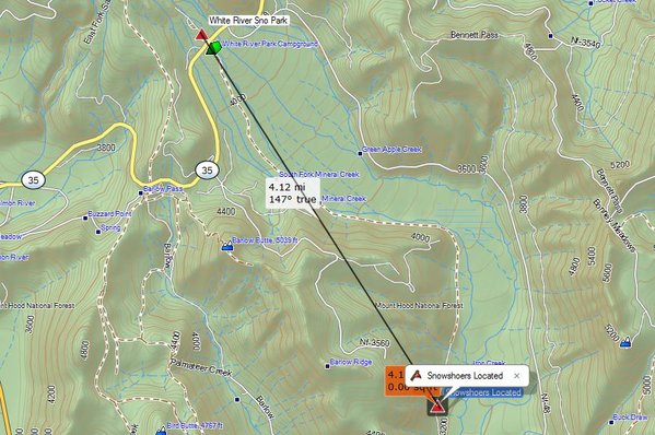
Topo map showing the lost snowshoers - rescued 4.2 miles from their cars
Copyright 2012 by KGW.com
Portland Mountain Rescue finds three hikers lost on Mount Hood
Portland Mountain Rescue finds three hikers lost on Mount
Hood
Monday, December 24, 2012
Portland Mountain Rescue had the privilege of giving three backcountry travelers
the gift of coming home safely to their families for the holidays. On Saturday,
December 22, 2012, the party of three adults left the White River West Snopark
bound for the White River Hut for the night to celebrate a birthday. They were
attempting to follow the Mineral Creek Trail on the south side of State Highway
35.
Over six feet of snow had accumulated in the area during the prior week and snow
was still coming down. Breaking trail through deep snow in challenging terrain
combined with difficulty finding and staying on the trail impeded their progress
and exhausted them. The two women were on snow shoes and the man was on cross
country skis. They were unable to find the hut before dark and kept searching
through the night.
Understanding their predicament, they moved about in attempts to obtain a
connection on their cell phone. They managed to connect to 911 sometime early on
Sunday, but the connection was poor. The 911 system was unable to get a fix on
their location through the phone’s GPS.
On Sunday, the Hood River County Sheriff’s Office activated the Crag Rats to
search the White River area north of Highway 35, which was the area suggested by
the limited information available by estimating their location from the cell
phone signal. The Crag Rats did not locate them before dark and the search was
curtailed until Monday morning. Sometime Sunday afternoon, the lost party
managed to establish a good cell phone connection and communicated their exact
coordinates to the Sheriff. This location was near Mineral Creek about 4 miles
southwest of the snopark on Highway 35.
Sunday night, the Sheriff asked Portland Mountain Rescue to assist searching on
Monday. Twelve PMR members and three rescuers from the Crag Rats formed three
teams at dawn on Monday. Two teams were inserted by snow cats that transported
them south on different Forest Service roads. The third team traveled on skis
down Mineral Creek, attempting to follow the trail. All three teams intended to
search different routes and converge on the coordinates the lost party gave the
sheriff.
By 10:15 a.m., the first team to reach the coordinates quickly made contact with
the lost party using voice and whistle calls. The three were tired, cold and
hungry, but otherwise healthy. After hot drinks and high calorie snacks, the
party agreed they could travel on foot aided by the rescuers. The quickest
evacuation route required climbing a steep 1000 vertical feet and about a mile
to reach a snow cat waiting on a ridge. Deep snow, heavy packs, challenging
terrain and inadequate gear made this an exhausting and slow endeavor for the
lost party, even with considerable help from the rescuers. After a three-hour
effort, everyone was loaded on the snow cat and they arrived back at the snopark
to waiting family and friends around 3:00 p.m.
Portland Mountain Rescue urges back country travelers to check and understand
back country conditions before setting out. Set objectives consistent with the
conditions and the skill and strength of your party. Research unfamiliar
territory and plan navigation in advance. Plot waypoints on your map and enter
them in a GPS. Then set a turn-round time and head back to safety if you have
not reached your destination by that time.
http://www.pmru.org/pressroom/headlines/20121224-ChristmasEveRescue.html
What can be learned from this interesting incident?
We have been unable to talk to the stranded hikers. Federal HIPPA privacy laws prevent medical personnel, including SAR Volunteer Units, from providing contact information for patients. If Mark Kelsey, Margarita Estrada and Deborah Shindler of Oregon will contact us, we will correct any inaccuracies in our analysis. This analysis is not a 'could-a, would-a, should-a exercise', but a traditional effort to help folks learn valuable lessons from the experiences of other climbers.
From news reports, "Three people who got lost while snowshoeing since Saturday were brought back to safety by rescuers Monday afternoon and were reunited with family members. Search and Rescue teams were activated Sunday afternoon after Mark Kelsey, an experienced mountaineer, Margarita Estrada and Deborah Shindler got lost and spent the night in cold conditions on Mount Hood. Just after 10:30 a.m. Monday, the snowshoers were all found safe. Search team members then spent most of the day leading them off the mountain and back to the White River West Sno Park on Highway 35 where they started their excursion. They arrived at the snow park at about 3:30 p.m."
"The Hood River County Sheriff's Office initially said the group planned on camping overnight and were equipped with sleeping bags and food. But later it was learned the group did not have any sleeping bags and very little food. The trio initially called for help Sunday afternoon while trying to reach a 'rustic cabin', according to Russell Gubele with Mountain Wave Search and Rescue."
Note the significant differences in the details in the three accounts of this search and rescue. The Leader used cross country skis, the followers had to break their own trail in deep snow, on snowshoes.
The three adults -two novices and their Leader- individually failed to Prepare based on the widely accepted "Ten Essential Systems"
Note that the trio was exposed for two nights and three days, almost completely un-prepared for the forecast mild wet winter weather on Mount Hood in December, and rescued about 4.2 miles from their cars!
Were they Prepared for their adventure? Based on my 40 years experience in traditional mountaineering education, I find from the news reports and video and from accounts by the trio, that the two women and their Leader had completely underestimated the inherent risks of their specific adventure and individually lacked most of the traditional essential individual trip, season and weather dependent light weight preparedness gear, suggested by The (Seattle) Mountaineers' Ten Essential Systems, the standard list nationwide, for more than eight years.
The Ten Essential Systems detail how each individual on a hike or ride or climb can Be Prepared for an almost inevitable unexpected event that might lead to a stranding overnight or longer, by carrying a light day pack with individual sized, seasonal, weather forecast and trip objective related items selected from this traditional list: 1-Navigation, 2-Sun Protection, 3-Insulation, 4-Illumination, 5-First Aid, 6-Fire Starter, 7-Tools, 8-Nutrition, 9-Hydration, 10-Emergency Shelter and (11)-Communication. What do you carry in your day pack in the winter?
Specifically:
1. Navigation: "A GPS device the group carried indicated
several trails to the cabin, but the one they took had been washed out when the
White River flooded. The three then hiked for about 20 hours looking for the
trail but were unsuccessful."
It seems clear that they did not have the correct USGS 1:24,000 Quad topo map, $8.00, or a declination adjusted (16 degrees east) clear baseplate compass, $25.00, to find their way without a current GPS.
I seems clear that they did not have a "GPS device", a common hand held current GPS DOD satellite receiver such as the Garmin eTrex Venture HC $150.00, with an internal 1:24,000 topo used by millions of ordinary folks world wide -for Geocaching- finding multi millions of geographic points, for adventure travel and hunting or the skills to relate their highly accurate GPS geographic location to a paper Quad topo map or to the ground.
I understand that they used a smart phone with a "GPS" navigation application. Their inability to GO TO the rustic cabin or to return to the point where they left the trail or to their car is typical of a costly cell phone "navigation app" designed for commercial motorized travel. To follow a pointer on the GPS to 'GO TO' a simple waypoint is a hallmark of the hand held GPS. The radio receiver is linked to the DOD military satellite system in the sky overhead, not to commercial cell phone towers serving population centers.
2. Sun Protection: The forecast called for snow showers. This was not known to be a factor
3. Insulation (Clothing layers): The three kept on the move for 20 straight hours. "All night long, we couldn't stop," Shindler said. Around 5 a.m. Sunday, they paused and made coffee, hot chocolate and peanut butter-and-jelly sandwiches. Estrada was wet and cold, Shindler said, and "we couldn't get a fire going."
Clearly, they survived more than two days and nights outside in stormy weather, so they had enough clothing insulation to survive. Moving for 20 hours overnight was necessary to avoid hypothermia from clothing insulation wet from melted snow and perhaps sweat. Maintaining their high level of activity kept them from becoming hypothermic, but they suffered at night. We note that the women are pictured upon return to the snow park, in borrowed SAR waterproof-breathable shells, Waterproof-breathable shells may seem unnecessary in cold snowy weather. But waterproof-breathable shells should be carried on all but the most warm summer days and windless nights at lower elevations. What do you wear in the winter?
4. Illumination: They must have had headlamps or flashlights to travel during the night for a continuous 19 hours through difficult steep terrain to stay moving and warm the first night. They stayed in place, 'sheltered' in a tree well with the increasingly cold night air pooling in the tree well, the second night.
5. First Aid, such as big Band-Aids and personal pills: It is unreported what personal first aid supplies each individual carried. Why are First Aid Kits dangerous?
6. Fire Starter: "Estrada was wet and cold, Shindler said, and 'we couldn't get a fire going'."
They were unable to start a "warming fire" in the Winter conditions, even though they had a small backpacking stove to help get a fire started. In our personal experience, it is almost impossible to start a warming fire in the three wet seasons of Central Oregon when a fire would be most helpful. 'Making a warming fire' seems to be foundational to most Survivalist Instruction, (a cottage industry for many).
7. Tools, such as a sharp little Swiss Army knife and duct tape. Unreported.
8. Nutrition: "The Hood River County Sheriff's Office initially said the group planned on staying overnight in a "rustic cabin' equipped with insulating pads and sleeping bags. But later it was learned the group did not have any sleeping bags and very little food."
The so called 'rustic cabin' was actually a small metal trailer hauled up a forest road in the Fall season and rented for $100.00 and more, by a business, under permit from the Forest Service, to winter visitors to Mount Hood. Cascade Huts.
The human body creates heat from exercise of the large muscles and the chemical work of digesting food. Read more: Calorie and Fluid Replacement during traditional alpine climbing.
9. Hydration: Their Guide carried a backpacking stove and a pot which they used to melt snow for drinking water. (It is dangerous to "eat snow" while inactive because it chills the body and helps induce Hypothermia).
Without hydration, the blood thickens and circulation is slowed - speeding a downward slope to Hypothermia.
10. Emergency Shelter: "With the help of Kelsey's experience, the group built a 'snow cave' for protection against the elements." "(We) tried to sleep. We had nothing to sleep on," said Estrada. "Thank God we had Mark – we built a snow cave and tried to sleep, but couldn't sleep. And so these guys (the rescuers) saved us."
The three hikers clearly lacked the ability to build a traditional Snow Cave. They lacked the tools (two light weight snow shovels) and likely, the snow depth, to construct a "Snow Cave" defined as being dug upward into a deep snow drift, having thick insulating snow walls and a thick domed roof enclosing a 'bench' situated above the top of the entrance (to trap the air warmed by the occupants breath and radiated body heat). Snow caves can be dangerous.
They constructed a "snow shelter", not a snow cave. They spent the second night in a tree well covered with branches and new snow. A tree well acts as a trap for the coldest air moving down slope nearby. Warmed air escapes up and away in a 'snow shelter', the opposite of a 'Snow Cave' that traps the warmed air from the occupants.
Note that each person lacked an Essential 6 oz. personal insulating pad $16.00, a mandatory Essential for winter adventures, to protect them from lying in compressed clothing directly on the snow or frozen foliage.
Hikers at elevation in the Fall should carry Essential Shelter in the form of a two pound all-season single wall tent and a 6 oz. insulating pad. A hiking companion might carry a light sleeping bag for an emergency bivy, overnight.
11. Communication: "They decided to call for help, getting in touch with a 911 dispatcher, and rescuers were able to pin down their location after their GPS device was able to send out a brief signal."
Note that they continued moving to stay warm and to try to find their way for 20 hours before calling 911, waiting an un-necessary 20 hours, risking loss of battery power for their one cell phone. At first, they connected with only one tower and a triangulated position was not obtained, only a broad liner position. It appears that they had good cell phone reception the second day, from more than one cell tower, since their digital cell phone's Provider was able to "ping" their phone and give SAR (through 911) their geographic (UTM-NAD 27) location by triangulation from two or more cell towers (according to one source). FCC E911 Requirements for Providing Mobile Phone Geographic Locations
Note that it is unlikely that a GPS was involved in any way. 'GPS' stands for 'Global Positioning System', a constellation of satellites operated by the Department of Defense to provide world wide geographic locations to all ships, aircraft and land based users. It is used by surveyors to pinpoint locations to the fraction of an inch. Russia operates a similar constellation. Some current inexpensive hand help Garmin GPS receivers use both the American and Russian GPS Systems, simultaneously. Only a more expensive smart phones contain a GPS chip. Verizon does not use "GPS" to provide geographic locations, they use the triangulation of recorded pings. The cell phone industry has co-opted the term "GPS position" from Garmin and other actual GPS navigation devices introduced in cars and trucks to follow a moving point on a planimetric road map. The cell phone is a communication device that has the unique ability to give SAR its location The sense of cell
We can assume that two more personal cell phones were left behind in a conscious decision that "one cell phone would do". Not so, of course: Three cell phones equal three phone batteries, perhaps more than one Provider, with three times the Essential Communication ability as one cell phone.
Mt. Hood is not a community park. Visitors are expected to Be Prepared with individual seasonal, weather and trip-related selected essential items from each of the Ten Essential Systems.
But, of course, the three snowshoe hikers did not intend to become lost and stranded over-night, let alone two nights. But that may not be a good reason to be so Unprepared.
Times have changed, each hiker should carry their cell phone!
Ordinary cell phone coverage has improved, year by year, to the time of this writing in 2012 - see below for "The Rest of the Story". Check and learn your own cell coverage in your favorite backcountry areas. Much of the High Desert, the Three Sisters Wilderness and Mt. Hood now is covered by Verizon using CDMA code. The cell phones from other (urban) providers are not able to "see" CDMA towers and will not connect.
With contact with two or more towers, a geographic location can be triangulated for 911 use and an accurate geographic location can be fixed. The one personal cell phone carried by the three hikers must have been low on battery power. Although not covered in the SAR report, we assume that this phone was able to ping at least two towers to enable the required triangulation from two or more towers to provide the FCC required geographic Coordinants to find them on a topo map.
Each person in a group should carry their own simple regular personal cell phone. We believe these hikers made a conscious decision to leave two cell phones at their car. (Solo hikers can carry a very inexpensive second cell phone battery.)
Some "smart phones" are sold with a second back up battery. Most of the cell phone batteries exhausted in search and rescues, are in so called Smart Phones. It seems that showing a map of the major trails, names and locations of prominent points, photos of views from points on the trail, keeping an electronic compass going, taking your photos and playing your tunes, while searching for better tower signals is more a phone battery can bear, no matter how smart the phone is.
Map, compass and GPS together
Back country travelers should carry a base plate declination adjustable compass costing $25.00 a $7.00 topo map annotated with the UTM Geographic Coordinant Grid and simple current model Garmin GPS costing as little as $100.00.. A stranded person can take the search out of SAR by simply reading the UTM Geographic Coordinants to the Incident Commander over the cell phone. Consider a $100.00 SPOT-2 Satellite Messenger if cell phone towers may not cover the area you plan to explore.
Read below for some basic suggestions about how to Be Prepared in 2012. Basic Responsibilities and the Ten Essential Systems.
Google each one of these three search phrases: Best Compass for backcountry Best topo maps for backcountry Best GPS for backcountry use Best cell phone for backcountry use
Millions of ordinary people world wide, use a common $150.00 hand held Garmin eTrex GPS with a topomap and color screen, for geocaching, hiking, hunting, cross country skiing, etc. Most GPS receivers have at least 14 hours of continuous life on two new batteries. Two extra AA batteries can be carried in a warm pants pocket to change out batteries weakened by cold. Lithium batteries withstand the cold much better than "regular" AA batteries. Note that it is not necessary to keep the ordinary GPS receiver on all the time, extending it's use potentially to many days.
The rest of the story
Deschutes County Sheriffs Search and Rescue
Volunteer Coordinator Al Hornish, a 12 year veteran of DCSAR, stated the
following in an interview published on January 26, 2012 in the Bend Oregon
Source Weekly:
"We have grown a lot over the past decade." "The nature of missions has changed
as well. There are more Rescues and less Searches, mostly because of the better
technology available."
Read More.
--Robert Speik, January 26, 2012
FIFTEEN WEEKS
Wednesday, July 7, 2010, or nearly four months since my fall off Mount Temple.
After so much time, there is much to dwell on. The negatives: the pain of so
many fractures, the sleeplessness, the drugs and the messed up things they do to
you. It’s easy to get stuck in the negative; yet some part of me is drawn there by some morbid fascination.
How big am I then? Not very. I made a mistake, a pretty small mistake. Or
more honestly, I made a series of pretty small mistakes. I almost died for these
transgressions. I would have died if it had not been for a cell phone and the
chain of events it was able to put into motion. (I’ve owned a cell phone for
barely six years.) I might not have died that very day, March 25, 2010, but from
where we were, we were a long, long way from the medical care my injuries
demanded: a trained trauma surgeon in an Emergency Room. Perhaps I would have
lasted one night. Maybe not. It changes my perspective about what a day means.
Carpe diem no longer seems some frat-boy cry to party. Today, means everything.
The Steve House Training Blog
Deschutes County Sheriff's Search and Rescue
Deputy Jim Whitcomb, assistant SAR coordinator reports on a recent 911 "false
alarm". He notes that the inadvertent activation happened in a pack with an
older SPOT-1 device. Whitcomb said it was a first-generation version
that’s easier to accidentally set off while in a pack. “It is important to
remember that technology can be a great asset, but can just as easily be a
liability,” the deputy said in a news release, urging users of such devices to
regularly monitor such gear. SAR will respond to all SPOT activations, treating
them as an emergency, unless contact can be made with whoever is carrying the
device, to confirm otherwise, Whitcomb said.
Read More,
--Robert Speik, July 22, 2012
Here are some Basic suggestions for all backcountry travelers
1. Practice the Four Basic Responsibilities of the Backcountry Traveler. They work! Basic Responsibilities
2. Carry the new Ten Essential Systems, sized for the forecast weather and the adventure in a light day pack. This includes a map, compass and GPS and the skills to use them. In the winter, this includes enough extra insulation and waterproof clothing to keep you dry and warm if you become stranded. In snow, you must have a shovel and insulating pad and the skills to make a shelter in the snow to avoid hypothermia and frost bite damage. It works! Ten Essential Systems
3. Carry your fully charged digital cell phone and periodically check where it can communicate with any cell towers to assist authorities to triangulate your position from cell tower pings. (Most cell providers do not use internal cell phone GPS radio signals to locate customers under FCC E911 regulations - they use triangulation). Cold disables batteries. If the weather is cold, carry the cell phone in a pants pocket near the femoral artery. Report your UTM NAD27 coordinates, your condition, the conditions where you are and discuss your plans with SAR. Ordinary Cell Phones If you are adventurous and often may be out of cell tower range, carry a $100.00 SPOT. SPOT-2 Satellite Messenger
4. Always stay found on your topo map and be aware of major land features. If visibility starts to wane, reconfirm your bearings with your map, compass and GPS and quickly return to a known location. A GPS is the only practical way for a trained individual to navigate in a whiteout or blowing snow. Lost Mt Hood Climbers
A suggested minimum standard news advisory for all backcountry travelers!
"We would like to take this opportunity to ask our visitors to the backcountry
of Oregon to Plan for the unexpected. Each person should dress for the forecast
weather and take minimum extra clothing to provide
protection from a drop in temperature and possible rain or snow storm or an
unexpected cold wet night out. Each person should carry high carbohydrate
snacks, two quarts of water or Gatorade, a topo map and
declination adjusted base plate compass and an optional inexpensive GPS (and the
skills to use them together). Each person who has a cell phone should carry
their ordinary charged cell phone (from a service
provider that has the best local backcountry coverage). An inexpensive SPOT-2
GPS Satellite Communicator is a good additional option for some. Each person
should carry their selected items from the new 'Ten
Essentials Systems' in a day pack sized for the individual, the trip, the season and the forecast weather."
"Visitors are reminded to tell a Responsible Person where they are going, where
they plan to park, when they will be back and to make sure that person
understands that they are relied upon to call 911 at a certain time if the
backcountry traveler has not returned. Call 911 as soon as you become lost or
stranded. You will not be charged. Do not try to find your way, becoming benighted, exhausted, or worse yet - wet. Your
ordinary cell phone call to 911 and conversation with SAR, can take the 'Search' out of Search and Rescue."
THE MISSION of TraditionalMountaineering.org
"To provide information and instruction about world-wide basic to advanced alpine mountain climbing safety skills and gear, on and off trail hiking, scrambling and light and fast Leave No Trace backpacking techniques based on the foundation of an appreciation for the Stewardship of the Land, all illustrated through photographs and accounts of actual shared mountaineering adventures."
TraditionalMountaineering is founded on the premise that "He who knows naught, knows not that he knows naught", that exploring the hills and summitting peaks have dangers that are hidden to the un-informed and that these inherent risks can be in part, identified and mitigated by mentoring: information, training, wonderful gear, and knowledge gained through the experiences of others.
The value of TraditionalMountaineering to our Friends and Subscribers is the selectivity of the information we provide, and its relevance to introducing folks to informed hiking on the trail, exploring off the trail, mountain travel and Leave-no-Trace light-weight bivy and backpacking, technical travel over steep snow, rock and ice, technical glacier travel and a little technical rock climbing on the way to the summit. Whatever your capabilities and interests, there is a place for everyone in traditional alpine mountaineering.
![]()
![]()
![]() WARNING - *DISCLAIMER!*
WARNING - *DISCLAIMER!*
Mountain climbing has inherent dangers that can, only in part, be mitigated
Read more . . .
Three snowshoe hikers found by SAR after two cold nights on Mt. Hood
Hurt Hiker dead but for cell call to 911
Hikers found by SAR on Tam McArthur Rim in November
Two Lost Hikers Found Near Tam McArthur Rim in July
Lost Hood climber posts to Facebook before rescue
Angeles Forest solo hiker dies in June 2012 - what can be learned?
Pole Creek Fire including Google Map, adjust scale for good detail
South Sister climber injured, rescued with helicopter
Lost hiker rescued near Horse Lake by SAR
Lost Mt. Bachelor skier rescued at Nordic shelter
FCC requirements for providing mobile phone geographic locations
Four lost in forecast storm on Mt. Rainier
Mt. Rainier snowshoe leader falls, rescued after two days
Climber dies in forecast storm on Mt. Rainier
The Episcopal School Tragedy
SPOT Satellite Messenger "PLB" reviewed and recommended
How do you use your map, compass and GPS together, in a nut shell?
Why is the GSM digital cell phone best for backcountry travel and mountaineering?
How do GSM mobile phones assist mountaineering and backcountry rescues?
FREE Clinic on Real Survival Strategies and Staying Found with Map, Compass and GPS together
Two climbers become lost descending Mt. Hood's standard South Side Route
What do you carry in your winter day and summit pack?
Why are "snowcaves" dangerous?
Why are "Space Blankets" dangerous?
Why are "Emergency Kits" dangerous?
How can you avoid Hypothermia?
Final Report to the American Alpine Club on the loss of three climbers on Mount Hood in December 2006
Missing climbers on Mount Hood, one dies of exposure, two believed killed in fall
Missing California family found, dad dies from exposure and hypothermia
Missing man survives two weeks trapped in snow-covered car
Missing snowmobile riders found, Roger Rouse dies from hypothermia
Olympic Champion Rulon Gardner lost on snowmobile
Lost Olympic hockey player looses feet to cold injury
Expert skier lost five days near resort in North Cascades without map, compass, gps or cell phone
Mount Hood - The Episcopal School Tragedy
Mount Hood - experienced climbers rescued from snow cave
How can you learn the skills of snow camping?
Prospectus
![]() Lost and Found
Lost and Found
Lost hiker rescued near Horse Lake by SAR
How can I prevent, recognize and treat Hypothermia?
Op-Ed: Prepare for the worst before setting out in the winter
Prineville hunter lost 4 winter days and 3 nights in the Ochoco National Forest
Several hikers lost near Sisters, rescued by SAR
Snowshoer, "lost" near Wanoga snowpark, rescued by SAR
"Be Prepared" to be stranded on winter forest roads in Oregon
Several drivers become stranded on Oregon winter forest roads, led their new GPS' "fastest way" setting
Gear grist, an article written for The Mountaineer, the monthly newsletter of The Mountaineers
Robert Speik writes: "Use your digital cell in the backcountry" for The Mountaineer
Teen girls become lost overnight returning from hike to Moraine Lake
Snowboarder lost overnight near Mount Bachelor, rescued by SAR
Woman leaves car stuck in snow near Klamath Falls, dies from exposure
Man rescued from crevasse just off South Sister climber's trail
Climbing South Sister: A Prospectus and a Labor Day near disaster
Trail runner survives fall on ice with cell phone call
Once again, hypothermia kills stranded Oregon driver
Lessons learned from the latest lost Mt. Hood climbers
Lessons learned from the latest lost Christmas tree hunters
New rescue services for all American Alpine Club Members
OpEd: Oregon requires electronic communications in the backcountry
Rescue charges in traditional alpine mountaineering
Governor establishes a Search and Rescue Task Force
Oregon Search and Rescue Statutes
Lost hiker in Oregon backcountry found with heat-sensing device in airplane
HB2509 mandates electronic locator beacons on Mt. Hood - climbers' views
Oregon HB 2509
Three hikers and a dog rescued on Mt. Hood
Motorist stuck in snow on backcountry Road 18, phones 911 for rescue
Snow stranded Utah couple leave car and die from hypothermia
Death on Mt. Hood - What happened to the three North Face climbers?
![]()
Two climbers become lost descending Mt. Hood
Missing California family found, dad dies from exposure and hypothermia
Missing man survives two weeks trapped in snow-covered car
Missing snowmobile riders found, Roger Rouse dies from hypothermia
Lost snowmobile riders found, one deceased from hypothermia
Lost climber hikes 6.5 miles from South Sister Trail to Elk Lake
Hiking couple lost three nights in San Jacinto Wilderness find abandoned gear
Expert skier lost five days in North Cascades without Essentials, map and compass
Climber disappears on the steep snow slopes of Mount McLaughlin
Hiker lost five days in freezing weather on Mount Hood
Professor and son elude search and rescue volunteers
Found person becomes lost and eludes rescuers for five days
Teens, lost on South Sister, use cell phone with Search and Rescue
Lost man walks 27 miles to the highway from Elk Lake Oregon
Snowboarder Found After Week in Wilderness
Searchers rescue hiker at Smith Rock, find lost climbers on North Sister
Girl found in Lane County after becoming lost on hiking trip
Search and rescue finds young girls lost from family group
Portland athlete lost on Mt. Hood
Rescues after the recent snows
Novice couple lost in the woods
Search called off for missing climber Corwin Osborn
Broken Top remains confirmed as missing climber
Ollalie Trail - OSU Trip - Lost, No Map, Inadequate Clothing
![]() Your Essential Light Day Pack
Your Essential Light Day Pack
What are the new Ten Essential Systems?
What does experience tell us about Light and Fast climbing?
What is the best traditional alpine mountaineering summit pack?
What is Light and Fast alpine climbing?
What do you carry in your day pack?
Photos?
![]()
What do you carry in your winter day pack?
Photos?
![]()
What should I know about "space blankets"?
Where can I get a personal and a group first aid kit?
Photos?
![]() Carboration and Hydration
Carboration and Hydration
Is running the Western States 100 part of "traditional mountaineering"?
What's wrong with GORP?
Answers to the quiz!
Why do I need to count carbohydrate calories?
What should I know about having a big freeze-dried dinner?
What about carbo-ration and fluid replacement during traditional alpine climbing?
4 pages in pdf
![]()
What should I eat before a day of alpine climbing?
![]() About Alpine Mountaineering:
About Alpine Mountaineering:
![]() The Sport of Alpine Mountaineering
The Sport of Alpine Mountaineering
![]() Climbing Together
Climbing Together
![]() Following the Leader
Following the Leader
![]() The Mountaineers' Rope
The Mountaineers' Rope
![]() Basic Responsibilities
Basic Responsibilities
![]() Cuatro Responsabiliades Basicas de Quienes Salen al Campo
Cuatro Responsabiliades Basicas de Quienes Salen al Campo
![]() The Ten Essentials
The Ten Essentials
![]() Los Diez Sistemas Esenciales
Los Diez Sistemas Esenciales
![]() Our Leader's Guidelines:
Our Leader's Guidelines:
![]() Our Volunteer Leader Guidelines
Our Volunteer Leader Guidelines
![]() Sign-in Agreements, Waivers and Prospectus
This pdf form will need to be signed by you at the trail head
Sign-in Agreements, Waivers and Prospectus
This pdf form will need to be signed by you at the trail head
![]() Sample Prospectus
Make sure every leader tells you what the group is going to do; print a copy for your "responsible person"
Sample Prospectus
Make sure every leader tells you what the group is going to do; print a copy for your "responsible person"
![]() Participant Information Form
This pdf form can be printed and mailed or handed to the Leader if requested or required
Participant Information Form
This pdf form can be printed and mailed or handed to the Leader if requested or required
![]() Emergency and Incident Report Form
Copy and print this form. Carry two copies with your Essentials
Emergency and Incident Report Form
Copy and print this form. Carry two copies with your Essentials
![]()
![]() Participant and Group First Aid Kit
Print this form. Make up your own first aid essentials (kits)
Participant and Group First Aid Kit
Print this form. Make up your own first aid essentials (kits)
![]()
![]() About our World Wide Website:
About our World Wide Website:
![]() Information
Information
![]() Mission
Mission
![]()
![]() Map, Compass and GPS
Map, Compass and GPS
Map, compass and GPS navigation training Noodle in The Badlands
BLM guidelines for Geocaching on public lands
Geocaching on Federal Forest Lands
OpEd - Geocaching should not be banned in the Badlands
Winter hiking in The Badlands WSA just east of Bend
Searching for the perfect gift
Geocaching: What's the cache?
Geocaching into the Canyon of the Deschutes
Can you catch the geocache?
Z21 covers Geocaching
Tour The Badlands with ONDA
The art of not getting lost
Geocaching: the thrill of the hunt!
GPS in the news
A GPS and other outdoor gadgets make prized gifts
Wanna play? Maps show you the way
Cooking the "navigation noodle"
![]()