 ™
™TRADITIONAL MOUNTAINEERING
™
www.TraditionalMountaineering.org
™ and also
www.AlpineMountaineering.org
™
™
FREE BASIC TO ADVANCED
ALPINE MOUNTAIN CLIMBING INSTRUCTION™
Home
| Information
| Photos
| Calendar
| News
| Seminars
| Experiences
| Questions
| Updates
| Books
| Conditions
| Links
| Search
![]()
Whoops: GPS locator switches on, sparks search - what happened?
Whoops: GPS locator switches on, sparks search
Father, sons found just fine; warning offered
KTVZ.com
By Barney Lerten
July 5, 2012
The GPS device a Washington state visitor had in his backpack for a hike at
Devils Lake, west of Bend, was a good thing to have – until it went off
accidentally Thursday, prompting an emergency response phone call and search for
the surprised man and his sons.
Deschutes County 911 dispatchers got a call around 4:40 p.m. from the
International Emergency Response Coordination Center to report the activation of
a SPOT GPS device, a locator beacon and communication system that can pinpoint
one’s location to within three meters, said sheriff’s Deputy Jim Whitcomb,
assistant SAR coordinator.
The coordinates given by IERCC for the whereabouts of Lance Peterson, 41, of
Battle Ground, Wash., pointed to an area of the Devils Lake Trail about 1 ½
miles from the lake, located about 30 miles southwest of Bend, Whitcomb said.
The coordination center spoke with Peterson’s wife back in Washington, she said
her husband was hiking in the area with their two sons, 11 and 13. Whitcomb said
they were planning to climb Broken Top and South Sister during a four-day trip.
Attempts to contact Peterson by cellphone and text message were unsuccessful,
the deputy said.
IERCC staff provided updated coordinates every five minutes, confirming the SPOT
device was continuing north up the trail, Whitcomb said.
Because they were unable to make contact with the Petersons about their status,
Sheriff’s Search and Rescue personnel headed to the area.
A “hasty team” of two members began a quick climb to the trail, followed by four
members of a medical support team, Whitcomb said. Two other three-member teams
began walking up the trail, ready to assist if circumstances changed.
Around 8 p.m., the hasty and medical support teams found Peterson and his sons,
in the process of setting up camp near Moraine Lake, Whitcomb said.
That’s when they learned the family’s SPOT device accidentally was activated
without his knowledge. Whitcomb said it was a first-generation version that’s
easier to accidentally set off while in a pack.
“It is important to remember that technology can be a great asset, but can just
as easily be a liability,” the deputy said in a news release, urging users of
such devices to regularly monitor such gear.
SAR will respond to all SPOT activations, treating them as an emergency, unless
contact can be made with whoever is carrying the device, to confirm otherwise,
Whitcomb said.
Copyright 2012 KTVZ. All rights reserved.
All Comments:
remsts
These are great units to wear on such trips. I have never heard of one being
activated in a pack, but things happen. Keep wearing these units, they can be a
life saver.
Larry2829Collapse
Nice job SAR! My family and I all carry SPOT's. It's nice knowing if we really
need help you guys are on the job. Thanks!!
alteredego
This reminds me of a T-Mobil phone I used to have that would dial 911
unintentionally. The cause was poor design.
Unpublished Comments:
Margaret Speik
We note that the "first line of defense is a Reliable Person", with a
time to call 911 and advise with SAR that the hiker
is overdue. A call at an agreed 4:30 pm is better than an embarrassed call from
the family at 9 pm, for both the hiker
and SAR. The information to be relayed to SAR should include the proposed Trail
Head, the make, model and color of the rig and the license number. SAR will want
to physically check that the hiker's car is unattended in the parking
area, confirming the need to call out the trained volunteers and set up "command
and control" communications at the Trail Head.
The informed Reliable Person is the best you can do, if you do not have an
inexpensive cell phone with basic service from a provider that covers the area
(say, the Three Sisters Wilderness). The best cost effective alternative is a SPOT-2
GPS/Satellite Messenger. SAR does
not respond with a rescue unless allerted, of course.
Robert Speik
Please note the three published comments. All three support the general use of the
$100.00 SPOT-2 GPS Satellite Messenger and no one complained
about "Yuppie 911 devices taxing search and rescue units".
Read More.
What can be learned from this interesting incident?
We have been unable to talk to Lance Petersen or his wife. Federal HIPPA privacy laws prevent medical personnel, including SAR Units, from providing contact information for patients. If Mr. Petersen will contact us, we will correct any inaccuracies in our analysis. This is not a 'could-a, would-a, should-a exercise, but a traditional effort to help others learn valuable lessons from the experiences of others.
Cell phones have increased in connection coverage, year by year. Check your favorite backcountry areas. Much of the high desert area and the Three Sisters Wilderness is covered by Verizon (CDMA encoded) cell phone towers. It is likely that Lance Petersen had switched off his cell phone to preserve battery power for his extended backpacking and climbing adventure. A cell phone call to the hiker is the basic first effort by SAR. Voice contact can resolve the issue of concern. A group with several ordinary cell phones can ensure communications over many hours if the Leader arranges for one to be on while the other cell phones can be kept warm and at hand in the pants pockets of several people.
Despite cell phone sales assertions, if the encoding of the cell provider's signal does not match the code of the cell tower, the phone can not connect, "roaming" or not!
Consider whether a family would benefit from a $100.00 SPOT-2 GPS Satellite Messenger. This relatively new device will send an email message home, "I'm OK and having fun exactly here on this Google map"; or message friends "I could use a little help, exactly here"; or send a message to 911 "I need help exactly here, right now - see the map attached," (thereby taking the Search out of Search and Rescue)!
It is noted that Petersen was using a SPOT-1 model which was superseded in 2009 by the $100.00 SPOT-2 model. Improvements over the original include a protective cap over the "911 button" and a stronger GPS/satellite communications antenna system. See below!
A smart cell phone "compass" and "GPS" will not work if the special cell phone battery is depleted. The SPOT-2 uses three common AA Lithium batteries. Always carry extra AA batteries for your SPOT-2 and Garmin GPS!
A $25.00 Suunto M-3 Leader declination adjusted base plate compass and a $7.00 USGS Quad topo map do not require batteries. They are traditional tools.
Note that it is not necessary to leave a $100.00 GPS on all the time! Most GPS receivers have at least 14 hours of continuous life on two new batteries. Extra common AA Lithium batteries can be carried in a warm pants pocket to change out batteries weakened by cold. Lithium batteries withstand the cold much better than "regular" AA batteries.
Note: In my personal experience, a costly smart phone with a monthly navigation "app" is more expensive and not nearly as detailed or accurate as a Garmin Venture HC or a Garmin eTrex 20 GPS loaded with 1:24,000 maps with a day to day and an affordable simple pocket cell phone. Leave your tunes, news, photo uploads and text messages at home! "Twitter and Facebook traffic declines each afternoon as their smart phone batteries expire!"
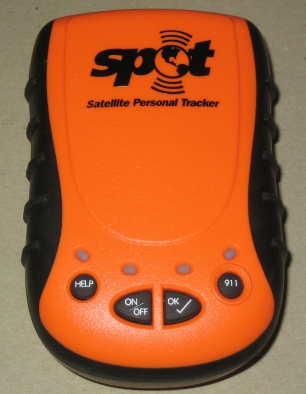
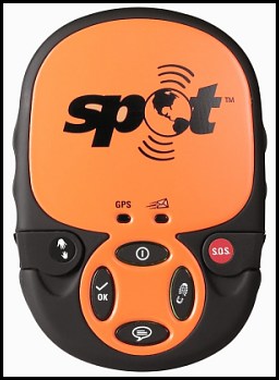
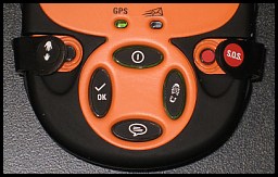
SPOT-1 (2007) and SPOT-2 (2009) with protective caps over the buttons. SPOT-2 sells today for $100.00 at REI. Either model connects automatically to the communications Satellites
The rest of the story
Deschutes County Sheriffs Search and Rescue
Volunteer Coordinator Al Hornish, a 12 year veteran of DCSAR, stated the
following in an interview published on January 26, 2012 in the Bend Oregon
Source Weekly:
"We have grown a lot over the past decade." "The nature of missions has changed
as well. There are more Rescues and less Searches, mostly because of the better
technology available."
Read More.
--Robert Speik, January 26, 2012
FIFTEEN WEEKS
Wednesday, July 7, 2010, or nearly four months since my fall off Mount Temple.
After so much time, there is much to dwell on. The negatives: the pain of so
many fractures, the sleeplessness, the drugs and the messed up things they do to
you. It’s easy to get stuck in the negative; yet some part of me is drawn there by some morbid fascination.
How big am I then? Not very. I made a mistake, a pretty small mistake. Or
more honestly, I made a series of pretty small mistakes. I almost died for these
transgressions. I would have died if it had not been for a cell phone and the
chain of events it was able to put into motion. (I’ve owned a cell phone for
barely six years.) I might not have died that very day, March 25, 2010, but from
where we were, we were a long, long way from the medical care my injuries
demanded: a trained trauma surgeon in an Emergency Room. Perhaps I would have
lasted one night. Maybe not. It changes my perspective about what a day means.
Carpe diem no longer seems some frat-boy cry to party. Today, means everything.
The Steve House Training Blog.
Deschutes County Sheriff's Search and Rescue
Deputy Jim Whitcomb, assistant SAR coordinator reports on a recent 911 "false
alarm". He notes that the inadvertent activation happened in a pack with an
older SPOT-1 device. Whitcomb said it was a first-generation version
that’s easier to accidentally set off while in a pack. “It is important to
remember that technology can be a great asset, but can just as easily be a
liability,” the deputy said in a news release, urging users of such devices to
regularly monitor such gear. SAR will respond to all SPOT activations, treating
them as an emergency, unless contact can be made with whoever is carrying the
device, to confirm otherwise, Whitcomb said.
Read More.
--Robert Speik, July 22, 2012
Here are some Basic suggestions for all backcountry travelers
1. Practice the Four Basic Responsibilities of the Backcountry Traveler. They work! Basic Responsibilities
2. Carry the new Ten Essential Systems, sized for the forecast weather and the adventure in a light day pack. This includes a map, compass and GPS and the skills to use them. In the winter, this includes enough extra insulation and waterproof clothing to keep you dry and warm if you become stranded. In snow, you must have a shovel and insulating pad and the skills to make a shelter in the snow to avoid hypothermia and frost bite damage. It works! Essential Systems
3. Carry a means of emergency communication. Each who has one, should carry their fully charged common digital cell phone and periodically turn it on to check where it can communicate with any cell towers. This will assist authorities on official request, to triangulate your position from cell tower pings. (Most cell providers do not use cell phone "GPS signals" to locate customers under FCC E911 regulations - they use cell tower triangulation). Cold disables batteries. If the weather is cold, carry the cell phone in a pants pocket near your femoral artery. Use common AA Lithium batteries in headlamps, flashlights, GPS receivers, SPOT-2, etc.. Call 911 and report your UTM NAD27 coordinates, your situation, the conditions where you are and discuss your plans with SAR. Ordinary Cell Phones If you may be out of cell tower range, carry a "SPOT-2". SPOT-2 Satellite Messenger
4. Always stay found on your topo map and be aware of major land features. If visibility starts to wane, reconfirm your bearings with your map, compass and GPS and return quickly to a known location. A GPS is the only practical way for a trained individual to navigate in a whiteout or blowing snow. Lost Mt Hood Climbers
A suggested minimum standard news advisory for all backcountry travelers!
"We would like to take this opportunity to ask our visitors to the backcountry
of Oregon to Plan for the unexpected. Each person should dress for the forecast
weather and take minimum extra clothing to provide
protection from a drop in temperature and possible rain or snow storm or an
unexpected cold wet night out. Each person should carry high carbohydrate
snacks, two quarts of water or Gatorade, a topo map and
declination adjusted base plate compass and an optional simple inexpensive
Garmin GPS (and the
skills to use them together). Each person who has a cell phone should carry
their ordinary charged cell phone (from a service
provider that has the best local backcountry coverage). An inexpensive SPOT-2
GPS Satellite Messenger is a good additional option for some. Each person
should carry their selected items from the new 'Ten
Essentials Systems' in a day pack sized for the individual, the trip, the season
and the forecast weather."
"Visitors are reminded to tell a Responsible Person where they are going, where
they plan to park, when they will be back and to make sure that person
understands that they are relied upon to call 911 at a certain
time if the backcountry traveler has not returned. Call 911 as soon as you
become lost or stranded. You will not be charged. Do not try to find your way
until you are benighted, exhausted, or worse yet - wet. Your
ordinary cell phone call to 911 can take the 'Search' out of Search and Rescue."
THE MISSION of TraditionalMountaineering.org
"To provide information and instruction about world-wide basic to advanced alpine mountain climbing safety skills and gear, on and off trail hiking, scrambling and light and fast Leave No Trace backpacking techniques based on the foundation of an appreciation for the Stewardship of the Land, all illustrated through photographs and accounts of actual shared mountaineering adventures."
TraditionalMountaineering is founded on the premise that "He who knows naught, knows not that he knows naught", that exploring the hills and summitting peaks have dangers that are hidden to the un-informed and that these inherent risks can be in part, identified and mitigated by mentoring: information, training, wonderful gear, and knowledge gained through the experiences of others.
The value of TraditionalMountaineering to our Friends and Subscribers is the selectivity of the information we provide, and its relevance to introducing folks to informed hiking on the trail, exploring off the trail, mountain travel and Leave-no-Trace light-weight bivy and backpacking, technical travel over steep snow, rock and ice, technical glacier travel and a little technical rock climbing on the way to the summit. Whatever your capabilities and interests, there is a place for everyone in traditional alpine mountaineering.
![]()
![]()
![]() WARNING - *DISCLAIMER!*
WARNING - *DISCLAIMER!*
Mountain climbing has inherent dangers that can, only in part, be mitigated
Read more . . .
![]() Map, Compass and GPS
Map, Compass and GPS
Whoops: GPS locator switches on, sparks search - what happened?
Locator beacons "supposedly" can take the Search out of Search and Rescue
OpEd: Yuppie 911 devices can take the Search out of Search and Rescue
![]()
Writer Doug Ritter evaluates SPOT II
SPOT Unveils Next Generation Satellite GPS Messenger at Outdoor Retailer
Staying found in the backcountry with map, compass and GPS
Exploring The Badlands with a simple GPS
SPOT Satellite Messenger "PLB" reviewed and recommended
Topographic maps of the backcountry work with your compass and GPS
Why is the digital cell phone best for backcountry travel and mountaineering?
Map, compass and GPS navigation training Noodle in The Badlands
BLM guidelines for Geocaching on public lands
Geocaching on Federal Forest Lands
OpEd - Geocaching should not be banned in the Badlands
Winter hiking in The Badlands WSA just east of Bend
Searching for the perfect gift
Geocaching: What's the Cache?
Geocaching into the Canyon of the Deschutes
![]()
Can you catch the geocache?
Z21 covers Geocaching
Tour The Badlands with ONDA
The art of not getting lost
Can I Geocache in The Badlands?
Geocaching: the thrill of the hunt!
Geocaching introduced to Central Oregon in 2002
GPS in the news
A GPS and other outdoor gadgets make prized gifts
Wanna play? Maps show you the way
Cooking the "navigation noodle"
![]() Lost and Found
Lost and Found
Whoops: GPS locator switches on sparks search
Lost Nordic skier and two dogs assisted by SAR
Lost Mt. Bachelor skier rescued at Nordic shelter
FCC requirements for providing mobile phone geographic locations
Lost Bend hiker turns up 20 miles away from rig
Searchers Find Lost Mountain Biker West of Bend
Searchers Find Lost Hiker Near Walton Lake
Two rescued in Three Sisters Wilderness
Three Stranded Hikers Assisted from Atop South Sister by SAR
Bend Teen Falls Into Crevasse on South Sister
Hikers Rescued After Long Night In Woods
Mountain Rescue Association's Position on Rescue Charges
Oregon Badlands camper lost overnight, found by SAR
Lost La Pine ATVer Rescued in Fortunate Encounter Twin Lakes Resort
How can I prevent, recognize and treat Hypothermia?
Op-Ed: Prepare for the worst before setting out in the winter
Lost Prineville hunter avoids hypothermia! What did he do right?
Oregon Badlands camper lost overnight, found by SAR
Cross country skier lost near Mt. Bachelor
New Hampshire fines Eagle Scout $25,000 for Rescue Services
What about climbing Mt. Washington, NH in the summer?
United States Coast Guard Position on Charging for SAR
How can I prevent, recognize and treat Hypothermia in the backcountry?
Stranded snowshoers Rescued Near Willamette Pass
Teen skier lost for nine hours in deep powder at Mt. Bachelor
Prineville hunter lost 4 days and 3 nights in the Ochoco National Forest
South Sister, solo hiker found unconscious near the summit
Three stranded hikers assisted from atop South Sister by SAR
Two novice climbers assisted by SAR on Mt. Adams
Several lost hiker incidents near Sisters, Oregon, resolved by SAR
Staying 'found' requires some basic skills
Snowshoer, "lost" near Wanoga snowpark, rescued by SAR
"Be Prepared" to be stranded on winter forest roads in Oregon
Several drivers become stranded on Oregon winter forest roads, led their new GPS' "fastest way" setting
Gear grist, an article written for The Mountaineer, the monthly newsletter of The Mountaineers
Robert Speik writes: "Use your digital cell in the backcountry" for The Mountaineer
Redpoint Climbers Supply looses everything to thieves
Teen girls become lost overnight returning from hike to Moraine Lake
Snowboarder lost overnight near Mount Bachelor, rescued by SAR
![]()
Woman leaves car stuck in snow near Klamath Falls, dies from
hypothermia
Man rescued from crevasse just off South Sister climber's trail
Climbing South Sister: A Prospectus and a Labor Day near disaster
Trail runner survives fall on ice with cell phone call
Once again, hypothermia kills stranded Oregon driver
Lessons learned from the latest lost Mt. Hood climbers
Lessons learned from the latest lost Christmas tree hunters
New rescue services for all American Alpine Club Members
OpEd: Oregon requires electronic communications in the backcountry
Rescue charges in traditional alpine mountaineering
Governor establishes a Search and Rescue Task Force
Oregon Search and Rescue Statutes
Lost hiker in Oregon backcountry found with heat-sensing device in airplane
HB2509 mandated electronic locator beacons on Mt. Hood - climbers' views
Oregon HB 2509
Three hikers and a dog rescued on Mt. Hood
Motorist stuck in snow on backcountry Road 18, phones 911 for rescue
Snow stranded Utah couple leave car and die from hypothermia
Death on Mt. Hood - What happened to the three North Face climbers?
![]()
Two climbers become lost descending Mt. Hood
Missing California family found, dad dies from exposure and hypothermia
Missing man survives two weeks trapped in snow-covered car
Missing snowmobile riders found, Roger Rouse dies from hypothermia
Lost snowmobile riders found, one deceased from hypothermia
Lost climber hikes 6.5 miles from South Sister Trail to Elk Lake
Hiking couple lost three nights in San Jacinto Wilderness find abandoned gear
Expert skier lost five days in North Cascades without Essentials, map and compass
Climber disappears on the steep snow slopes of Mount McLaughlin
Hiker lost five days in freezing weather on Mount Hood
Professor and son elude search and rescue volunteers
Found person becomes lost and eludes rescuers for five days
Teens, lost on South Sister, use cell phone with Search and Rescue
Lost man walks 27 miles to the highway from Elk Lake Oregon
Snowboarder Found After Week in Wilderness
Searchers rescue hiker at Smith Rock, find lost climbers on North Sister
Girl found in Lane County after becoming lost on hiking trip
Search and rescue finds young girls lost from family group
Portland athlete lost on Mt. Hood
Rescues after the recent snows
Novice couple lost in the woods
Search called off for missing climber Corwin Osborn
Broken Top remains confirmed as missing climber
Ollalie Trail - OSU Trip - Lost, No Map, Inadequate Clothing
![]() Your Essential Light Day Pack
Your Essential Light Day Pack
What are the new Ten Essential Systems?
What does experience tell us about Light and Fast climbing?
What is the best traditional alpine mountaineering summit pack?
What is Light and Fast alpine climbing?
What do you carry in your day pack?
Photos?
![]()
What do you carry in your winter day pack?
Photos?
![]()
What should I know about "space blankets"?
Where can I get a personal and a group first aid kit?
Photos?
![]() Carboration and Hydration
Carboration and Hydration
Is running the Western States 100 part of "traditional mountaineering"?
What's wrong with GORP?
Answers to the quiz!
Why do I need to count carbohydrate calories?
What should I know about having a big freeze-dried dinner?
What about carbo-ration and fluid replacement during traditional alpine climbing?
4 pages in pdf
![]()
What should I eat before a day of alpine climbing?
![]() About Alpine Mountaineering:
About Alpine Mountaineering:
![]() The Sport of Alpine Mountaineering
The Sport of Alpine Mountaineering
![]() Climbing Together
Climbing Together
![]() Following the Leader
Following the Leader
![]() The Mountaineers' Rope
The Mountaineers' Rope
![]() Basic Responsibilities
Basic Responsibilities
![]() Cuatro Responsabiliades Basicas de Quienes Salen al Campo
Cuatro Responsabiliades Basicas de Quienes Salen al Campo
![]() The Ten Essentials
The Ten Essentials
![]() Los Diez Sistemas Esenciales
Los Diez Sistemas Esenciales
![]() Our Leader's Guidelines:
Our Leader's Guidelines:
![]() Our Volunteer Leader Guidelines
Our Volunteer Leader Guidelines
![]() Sign-in Agreements, Waivers and Prospectus
This pdf form will need to be signed by you at the trail head
Sign-in Agreements, Waivers and Prospectus
This pdf form will need to be signed by you at the trail head
![]() Sample Prospectus
Make sure every leader tells you what the group is going to do; print a copy for your "responsible person"
Sample Prospectus
Make sure every leader tells you what the group is going to do; print a copy for your "responsible person"
![]() Participant Information Form
This pdf form can be printed and mailed or handed to the Leader if requested or required
Participant Information Form
This pdf form can be printed and mailed or handed to the Leader if requested or required
![]() Emergency and Incident Report Form
Copy and print this form. Carry two copies with your Essentials
Emergency and Incident Report Form
Copy and print this form. Carry two copies with your Essentials
![]()
![]() Participant and Group First Aid Kit
Print this form. Make up your own first aid essentials (kits)
Participant and Group First Aid Kit
Print this form. Make up your own first aid essentials (kits)
![]()
![]() About our World Wide Website:
About our World Wide Website:
![]() Information
Information
![]() Mission
Mission
![]()
![]()